1/16


AviNavi, navigation for pilots
1K+下载次数
29MB大小
4.5.7(08-01-2024)最新版本

详情评价版本信息
1/16
AviNavi, navigation for pilots介绍
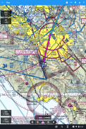
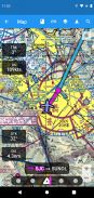
航空导航变得简单且经济实惠。适用于美国大陆的所有 VFR、低空 IFR 和仪表进近图,具有完整的飞行计划,包括对航路导航的支持。 Nexrad、METAR 和 AIRMETS/SIGMETS 的叠加可提高飞行安全性,详细的机场信息(跑道、频率、燃料、天气)触手可及。
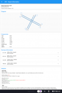
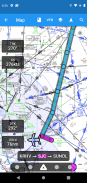
使用移动地图搜索或选择机场、VOR、NDB 或十字路口并开始直接导航,或添加到飞行计划中。或者以文本形式输入飞行计划,例如KPAO SUNOL V334 SAC KSAC 将加载完整的飞行计划,包括所有航路导航点。
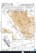
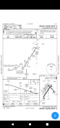
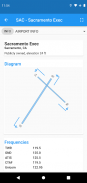
仪表进近图包括机场图、STARS、DP 和最小值,以及图例。
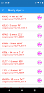
附近的机场以绿色或红色显示,以表明这些机场在无风滑翔的情况下是否可能到达。
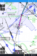
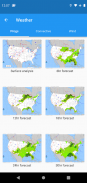
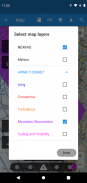
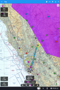
METAR、TAF、AIRMET、SIGMET、Prog 图表、对流展望和 Wind 可用作图形和/或文本信息。可以使用图层按钮将 METAR 和 AIRMETS/SIGMETS 叠加在地图上。机场信息以简单的英语显示 METAR 和 TAF,不同时间和高度的 Prog 图表、对流展望和风图以全屏图形形式提供。
在免费试用期之后,AviNavi 需要按月或按年订阅。
AviNavi, navigation for pilots - 版本4.5.7
(08-01-2024)新特性Improved NEXRAD image type and presentation

AviNavi, navigation for pilots - APK信息
APK版本: 4.5.7程序包: com.bbflight.avinavi名称: AviNavi, navigation for pilots大小: 29 MB下载次数: 158版本: 4.5.7发布日期: 2024-05-21 10:58:00最小屏幕: SMALL支持的CPU:
程序包ID: com.bbflight.avinaviSHA1签名: 19:D0:E8:1C:B4:A4:B0:24:CA:C8:43:2E:51:69:55:00:83:73:2E:B0开发商 (CN): 组织 (O): BBFlight LLC本地 (L): 国家/地区 (C): 州/市 (ST): 程序包ID: com.bbflight.avinaviSHA1签名: 19:D0:E8:1C:B4:A4:B0:24:CA:C8:43:2E:51:69:55:00:83:73:2E:B0开发商 (CN): 组织 (O): BBFlight LLC本地 (L): 国家/地区 (C): 州/市 (ST):
AviNavi, navigation for pilots的最新版本
4.5.7
8/1/2024158 下载次数2.5 MB 大小
其他版本
4.5.5
3/9/2023158 下载次数2.5 MB 大小
4.5.4
4/2/2023158 下载次数2.5 MB 大小
4.4.0
7/12/2022158 下载次数2 MB 大小
3.3.2
29/1/2021158 下载次数6.5 MB 大小


同类应用


English


